
1971 Map of Camilla
USGS Topo · Published 1974About this map
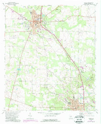
Camilla and Pelham serve as the primary hubs of this southwest Georgia landscape, connected by the diagonal corridor of the Seaboard Coast Line railroad. The agricultural character of Mitchell County is evident in the network of rural churches and cemeteries that dot the countryside between these towns, including Bethany Ch and St John Vianney Ch. Unique geological features like Tuggles Sink and the winding Big Slough break the pattern of cultivated fields and pecan groves.
Find a feature on this map
37 named features on this map. Tap any name to fly to it.
Don’t see what you’re looking for? This feature index may not catch every label — zoom into the map to look around manually.
Map Details
Editions of this 1971 Camilla Map
2 editions found
Other maps of this area

1953 · Dothan
USGS Topo · 1:250,000

1954 · Dothan
USGS Topo · 1:250,000

1955 · Dothan
USGS Topo · 1:250,000

1956 · Baconton
USGS Topo · 1:62,500

1956 · Newton
USGS Topo · 1:62,500

1971 · Meigs
USGS Topo · 1:24,000

1971 · Gee Pond
USGS Topo · 1:24,000

1971 · Cotton
USGS Topo · 1:24,000
1971 · Pelham
USGS Topo · 1:24,000
1971 · Branchville
USGS Topo · 1:24,000