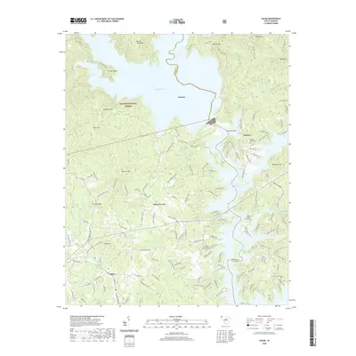
2020 Map of Salem
USGS Topo · Published 2020About this map
The town of Salem sits at the southwestern edge of this landscape, where the foothills meet the rising elevations of the Sumter National Forest. This modern record reveals a geography dominated by the massive impoundments of Lake Jocassee and Lake Keowee, which have transformed the historical drainage patterns of the Little River and Boones Creek. The area is characterized by several named peaks including McKinneys Mtn, Smeltzer Mtn, and Lydia Mtn, illustrating the transition from the Piedmont to the Blue Ridge mountains. For local history and genealogy research, the map labels several significant community landmarks. Settlements such as Jocassee, Eastatoe, and Boones Creek are depicted alongside religious and burial sites like Bethel Church, Fall Creek Baptist Church, and the McKinney Chapel Cem. These features, combined with a network of winding mountain roads like Whitewater Falls Rd and Smeltzer Mountain Rd, provide a modern perspective on a region deeply shaped by hydroelectric development.
Find a feature on this map
151 named features on this map. Tap any name to fly to it.
Don’t see what you’re looking for? This feature index may not catch every label — zoom into the map to look around manually.
Map Details
Editions of this 2020 Salem Map
This is the sole edition of this map. No revisions or reprints were ever made.
Other maps of this area

1886 · Walhalla
USGS Topo · 1:125,000

1888 · Pickens
USGS Topo · 1:125,000

1891 · Cowee
USGS Topo · 1:125,000

1892 · Walhalla
USGS Topo · 1:125,000

1894 · Pickens
USGS Topo · 1:125,000

1896 · Walhalla
USGS Topo · 1:125,000

1897 · Cowee
USGS Topo · 1:125,000

1905 · Pisgah
USGS Topo · 1:125,000

1906 · Pisgah
USGS Topo · 1:125,000

1907 · Cowee
USGS Topo · 1:125,000