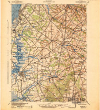
1941 Map of Salem
USGS Topo · Published 1941About this map
The Delaware River shorelines of Upper Penns Neck and Lower Penns Neck reveal an industrial and transport landscape during the early 1940s. Heavy industry and military-adjacent infrastructure are evident at Dupont Powders Co and a nearby Landing Field, while the Wilmington Ferry maintains a vital connection across the water. Inland, the map captures a rural network of small agricultural hamlets and crossroads such as Sharptown and Yorktown PO, connected by the Pennsylvania-Reading Seashore Lines. Water-powered history is preserved in labels for several local works, including Porches Mill and Russels Mill, which sit along the drainages of Oldmans Creek and the Salem River. This survey, revised by the 30th Engineer Battalion, documents the transition from a traditional milling economy to modern electrical and chemical infrastructure, evidenced by the Transformer Station near Milltown.
Find a feature on this map
106 named features on this map. Tap any name to fly to it.
Don’t see what you’re looking for? This feature index may not catch every label — zoom into the map to look around manually.
Map Details
Editions of this 1941 Salem Map
This is the sole edition of this map. No revisions or reprints were ever made.
Other maps of this area

1890 · Salem
USGS Topo · 1:62,500

1890 · Bay Side
USGS Topo · 1:62,500

1890 · Bridgeton
USGS Topo · 1:62,500

1890 · Glassboro
USGS Topo · 1:62,500

1891 · Philadelphia
USGS Topo · 1:62,500

1894 · Bay Side
USGS Topo · 1:62,500

1894 · Bridgeton
USGS Topo · 1:62,500

1894 · Chester
USGS Topo · 1:62,500

1894 · Philadelphia
USGS Topo · 1:62,500

1896 · Philadelphia
USGS Topo · 1:62,500