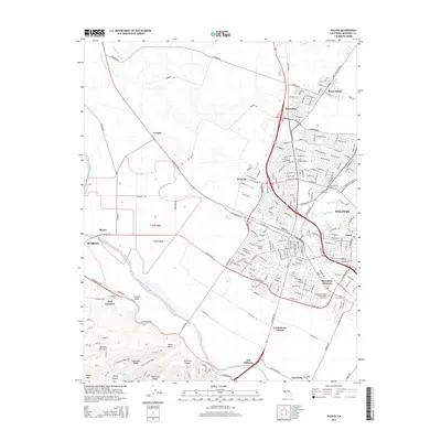
2015 Map of Salinas
USGS Topo · Published 2015About this map
Salinas serves as the hub of this mid-2010s landscape, where the urban grid meets the productive flats of the Salinas River valley. The map documents a dense network of civic and educational institutions, including Hartnell College and Heald College, alongside a significant cluster of memorial sites such as the Independent Order of Odd Fellows Cemetery and the Chinese Cemetery. To the south and west, the terrain shifts from the valley floor into the heights of Pilarcitos Ridge and Sandstone Ridge, revealing a history of military training indicated by Machine Gun Flats and the nearby East Garrison. The proximity of the Salinas River to settlements like Old Hilltown and Confederate Corners highlights the enduring relationship between the river's path and the development of Monterey County's agricultural and transit infrastructure at Spreckels Junction.
Find a feature on this map
214 named features on this map. Tap any name to fly to it.
Don’t see what you’re looking for? This feature index may not catch every label — zoom into the map to look around manually.
Map Details
Editions of this 2015 Salinas Map
This is the sole edition of this map. No revisions or reprints were ever made.
Other maps of this area

1910 · Salinas
USGS Topo · 1:31,680

1912 · Salinas
USGS Topo · 1:62,500

1912 · Capitola
USGS Topo · 1:62,500

1913 · Monterey
USGS Topo · 1:62,500

1914 · Capitola
USGS Topo · 1:62,500

1915 · San Juan Bautista
USGS Topo · 1:48,000

1917 · San Juan Bautista
USGS Topo · 1:62,500

1939 · San Juan Bautista
USGS Topo · 1:62,500

1940 · San Juan Bautista
USGS Topo · 1:62,500

1940 · Salinas
USGS Topo · 1:62,500