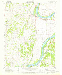
1971 Map of Saline City
USGS Topo · Published 1973About this map
The Missouri River defines the landscape of this 1970s survey, marking the jagged boundary where Saline, Howard, and Chariton counties meet. The river's winding course is flanked by significant alluvial features like Epperson Island and several drainage systems including Chocolate Creek and Fish Creek. Along the northern bluffs, the Gulf Mobile and Ohio railroad cuts a path through the terrain, connecting the settlement of Gilliam with West Glasgow near the river's edge.
Find a feature on this map
32 named features on this map. Tap any name to fly to it.
Don’t see what you’re looking for? This feature index may not catch every label — zoom into the map to look around manually.
Map Details
Editions of this 1971 Saline City Map
This is the sole edition of this map. No revisions or reprints were ever made.
Other maps of this area

1890 · Glasgow
USGS Topo · 1:125,000

1890 · Marshall
USGS Topo · 1:125,000

1892 · Marshall
USGS Topo · 1:125,000

1901 · Marshall
USGS Topo · 1:125,000

1940 · Marshall
USGS Topo · 1:62,500

1944 · Marshall
USGS Topo · 1:62,500

1947 · Glasgow
USGS Topo · 1:62,500
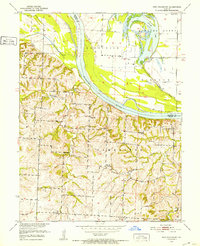
1951 · New Frankfort
USGS Topo · 1:24,000

1953 · Moberly
USGS Topo · 1:250,000

1954 · Moberly
USGS Topo · 1:250,000