Old Maps of Chariton County, Missouri
Explore 139 old maps of Chariton County, spanning from 1890 to today. These high-resolution historic maps reveal how streets, neighborhoods, landmarks, and natural features evolved over time — perfect for genealogy, metal detecting, research, and local history exploration.
What you can do with these maps:
- See how Chariton County changed over time: Compare historical maps to modern-day views to trace roads, homesites, rail lines & more.
- View detailed metadata: Each map includes creators, publishers, year, scale, and archive source.
- Overlay maps with satellite & LiDAR: Visualize the past alongside modern tools to explore terrain & human change.
- Trusted historical sources: Maps sourced from the USGS, Library of Congress, and other archives.
- Access maps your way: View online, download high-res files, or order prints for personal or research use.
Start exploring old maps of Chariton County to uncover forgotten places, hidden landmarks, and the deep history beneath your feet.
Chariton County, MO maps
(139)- 1890 Map of Glasgow
 1890 Glasgow1890 Print · USGSCentral Missouri in the late nineteenth century was a bustling intersection of river traffic and new rail lines. Genealogists and historians can trace family roots through riverfront towns like Arrow Rock and Glasgow, or locate rural sites like Jackman Mills and Whites Store.5 unique versions available
 - 1890 Map of Marshall
 1890 Marshall1890 Print · USGSSaline and Carroll counties come alive in this late nineteenth-century survey, showing the Missouri River bottomlands before modern channelization. Genealogists and historians can trace defunct river landings and rail stops like Eugene City, Laynesville, and Miami Station.
 - 1892 Map of Marshall, 1896 Print
 1892 Marshall1896 Print · USGSNorth-central Missouri in the 1890s is defined by its vibrant river commerce and expanding rail networks. Genealogists and historians can trace family roots through old settlements like Malta Bend, Laynesville, and Salt Springs along the Missouri River.
 - 1901 Map of Marshall
 1901 Marshall1901 Print · USGSCentral Missouri thrives along the river and rail lines at the turn of the century. Trace the early footprints of Marshall and Slater, or locate long-standing river landings and rural stations like Miami Station, Malta Bend, and Laynesville.5 unique versions available
 - 1924 Map of Hale
 1924 Hale1924 Print · USGSThe Grand River valley in the early 1920s reveals a landscape of winding waterways and rail-connected settlements at the borders of Livingston and Carroll counties. Genealogists can locate numerous country schools like Lowland School and Morgan School, or trace family roots near Grace Church and Avalon.4 unique versions available
 - 1947 Map of Glasgow
 1947 Glasgow1947 Print · USGSThe Missouri River bottomlands in the mid-1940s reveal a landscape of shifting channels and established river towns. You can trace early settlement patterns through numerous rural landmarks like Sappington Cem, Boonesboro, and Farmers High Sch.2 unique versions available
 - 1949 Map of Mendon
 1949 Mendon1949 Print · USGSChariton County at the end of the 1940s shows a landscape of rail-driven settlements and protected wetlands. Trace the junctions of the Wabash railroad at Whitham or locate old community landmarks like Stephenson Sch and Jackson Cem.3 unique versions available
 - 1949 Map of Indian Grove
 1949 Indian Grove1949 Print · USGSMid-century Chariton County comes to life here through its dense network of rural schoolhouses and country churches. You can trace early burial sites like Old Mendon Cem and locate vanished landmarks such as Woods Sch and the St Raphael Ch.4 unique versions available
 - 1949 Map of Sumner
 1949 Sumner1949 Print · USGSThe rail-and-river landscape of Chariton County is captured here in the late 1940s as agriculture and conservation efforts began to shape the terrain. Researchers can locate vanished landmarks like the Forker Boomer PO, rural schools such as Kaye Sch, and local resting places like Purvis Cem.2 unique versions available
 - 1949 Map of Rothville
 1949 Rothville1949 Print · USGSChariton and Linn Counties are captured here just after the war, showing a rural landscape defined by rail and creek bottoms. Researchers can trace ancestral locations through several country schools like Pershing Sch and landmarks like Stains Cem.2 unique versions available
 - 1950 Map of Sumner
 1950 Sumner1950 Print · USGSMid-century Chariton County comes to life at this rail junction where the Wabash line intersects the Chicago Burlington and Quincy. Genealogists can trace local roots at Purvis Cem, Prairie Mound Sch, and the Forker Boomer PO.2 unique versions available
 - 1950 Map of Rothville
 1950 Rothville1950 Print · USGSThe village of Rothville and the surrounding Chariton County countryside are shown here at the mid-century mark. Genealogists can trace early landmarks like Stains Cem, South Eagle Ch, and several rural schoolhouses including Pershing Sch and Holloway Sch.2 unique versions available
 - 1950 Map of Hale, 1956 Print
 1950 Hale1956 Print · USGSCarroll County was a landscape of river-bend lakes and rural schoolhouses in the mid-twentieth century. Genealogists can trace family footprints through sites like Elizabeth Cemetery or Hazel Hill School, while exploring the oxbows of the Grand River.2 unique versions available
 - 1951 Map of Hale
 1951 Hale1951 Print · USGSNorthwestern Missouri farming life and river management are preserved here in the early fifties. Genealogists can locate family landmarks like Elizabeth Cem, Winfrey Cem, and numerous rural schools including Battsville Sch.
 - 1951 Map of Bosworth, 1952 Print
 1951 Bosworth1952 Print · USGSBosworth and the rural townships of Carroll County are captured here at the start of the 1950s. Researchers can trace the legacy of early Missouri education and rail life through sites like West Fairview Sch, Mt Carmel Ch, and the ATCHISON TOPEKA AND SANTA FE line.4 unique versions available
 - 1951 Map of Brunswick West, 1952 Print
 1951 Brunswick West1952 Print · USGSThe river bottomlands of Chariton and Carroll Counties are captured here in the early 1950s, showing a landscape defined by the winding Missouri River. Genealogists and researchers can locate several rural schools such as Smith Sch and local burial sites like Allega Cem.4 unique versions available
 - 1951 Map of Brunswick East, 1952 Print
 1951 Brunswick East1952 Print · USGSChariton County, Missouri, is captured in the early fifties as the riverfront economy and rural school system underwent significant shifts. Genealogists can trace family landmarks and defunct rural districts like Warden Sch and Prairie Chapel Cem along the Wabash line.3 unique versions available
 - 1951 Map of Hale, 1952 Print
 1951 Hale1952 Print · USGSNorth-central Missouri's river lowlands are captured here in the early fifties, showing the area around Hale and the Grand River floodplain. Researchers can trace defunct rural infrastructure like Hazel Green Sch and the Sumner Bridge crossing.3 unique versions available
 - 1951 Map of New Frankfort, 1952 Print
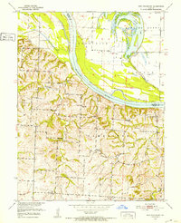 1951 New Frankfort1952 Print · USGSThe Missouri River bluffs and bottomlands of Saline County appear here in the early fifties, documenting a landscape of rural schools and family cemeteries. Genealogists can trace the locations of New Frankfort Cem, High Hill Sch, and Prospect Ch.2 unique versions available
 - 1953 Map of Moberly
 1953 Moberly1953 Print · USGSMid-century north-central Missouri is documented here as a bustling intersection of river commerce and heavy rail. Researchers can trace historic family-named landmarks and transport hubs from the Missouri River corridor to the rail yards of Moberly, Chillicothe, and Macon.
 - 1953 Map of Marceline, 1955 Print
 1953 Marceline1955 Print · USGSMarceline and the surrounding rural townships of north-central Missouri are shown here in the mid-1950s as the railroad remained a central economic force. Researchers can locate family landmarks like St Bonaventure Cem or trace the early layout of Marceline Airport and Park Sch.2 unique versions available
 - 1953 Map of Armstrong, 1955 Print
 1953 Armstrong1955 Print · USGSHoward and Randolph counties come alive in the mid-1950s as the rail-driven economy of the Missouri interior is captured in fine detail. Genealogists can trace family footprints at Wesley Chapel Cem, Sharon Sch, and the busy rail hub of Armstrong.2 unique versions available
 - 1953 Map of Clifton Hill, 1955 Print
 1953 Clifton Hill1955 Print · USGSRandolph and Chariton Counties come to life in the 1950s as the WABASH railroad connects the small community of Clifton Hill. Genealogists can trace family names through several rural burial grounds like Gross Cem and early school sites.2 unique versions available
 - 1953 Map of Prairie Hill, 1955 Print
 1953 Prairie Hill1955 Print · USGSNorth-central Missouri farming and mining communities come into focus in the mid-1950s. Genealogists and local historians can trace family locations near Prairie Hill, Cumberland Chapel, and the now-abandoned Old Grove Ch (Abandoned).2 unique versions available
 - 1953 Map of Lagonda, 1955 Print
 1953 Lagonda1955 Print · USGSThe border of Macon and Chariton Counties in the early fifties shows a landscape of small farming communities defined by the winding paths of the Old Channel Chariton River. Researchers can trace rural school locations like Minefree School and find family burial sites at Rice Cemetery or Dodson Cemetery.2 unique versions available
Showing maps 1-25 of 139
Top cities of Chariton County
- Salisbury historical maps
- Brunswick historical maps
- Keytesville historical maps
- Cunningham historical maps
- Mendon historical maps
- Sumner historical maps
See more
Frequently asked questions
- What are the different types of historical maps available for Chariton County?
- What is the oldest map of Chariton County?
- Where can I purchase historical maps of Chariton County for my home or office?
- Where can I download high-res historical maps of Chariton County?
- Are there historical topographic maps available for Chariton County?
- Is there historical aerial imagery available for Chariton County?
- Where are historical maps of Chariton County sourced from?