1980s Maps of Chariton County, Missouri
Explore 5 historic maps of Chariton County from the 1980s. These maps offer a rare glimpse into what life looked like during the 1980s — showing old roads, neighborhoods, homes, and landmarks that have changed or disappeared over time.
Whether you're researching your family's past, planning a metal detecting trip, or studying how Chariton County's landscape evolved across the 1980s, these high-resolution maps are a powerful tool for exploring the history of this region.
- Focus on a specific era: All maps on this page are from the 1980s, giving you a focused view of this time period.
- See what’s changed: Compare century-old streets, trails, and buildings to today's modern landscape using overlays and satellite layers.
- Research with precision: Use these maps for genealogy, historical research, land use analysis, or educational projects.
- View, download, or print: Maps are fully viewable online in high resolution, and can be downloaded or printed for your own records.
Start exploring Chariton County's history through authentic maps from the 1980s. This is your window into the past.
Chariton County, MO maps
(5)- 1981 Map of Chillicothe
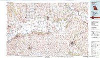
 1981 Chillicothe1981 Print · USGSNorth Missouri's Grand River basin comes into focus during the early 1980s, showcasing a network of vital rail lines and river settlements. Genealogists and historians can trace rail-town development from Gallatin to Brookfield and explore extensive conservation lands like Swan Lake National Wildlife Refuge.
 - 1981 Map of Macon
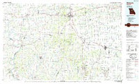
 1981 Macon1981 Print · USGSNorthern Missouri's rail-and-river landscape is captured here in the early eighties, centered on the crossroads of Macon. Researchers can trace old cemetery sites like St Marys Cem, local landmarks such as College Mound, and the routes of the Burlington Northern railroad.
 - 1982 Map of Marshall
 1982 Marshall1982 Print · USGSMid-Missouri river life and rail history meet in this early 1980s landscape, centered on the Missouri's winding course. Researchers can trace the historic Santa Fe Trail and explore sites like the Confederate Memorial State Park and Carrollton Mem Cemetery.
 - 1984 Map of Fountain Grove, 1985 Print
 1984 Fountain Grove1985 Print · USGSThe river bottoms of Livingston and Linn counties are captured here in the mid-1980s, showcasing a landscape shaped by water and rail. Genealogists and local historians can trace the paths of the Norfolk and Western railroad and locate rural settlements like Bedford and Towstring.
 - 1985 Map of Moberly
 1985 Moberly1985 Print · USGSCentral Missouri in the mid-eighties shows a landscape of rail-connected towns and active resource extraction across Randolph and Howard Counties. Genealogists and historians can locate family landmarks like Sunset Hill Cem or trace the Norfolk and Western RR through Moberly and Salisbury.2 unique versions available
End of results
Showing maps 1-5 of 5
Top cities of Chariton County
- Salisbury historical maps
- Brunswick historical maps
- Keytesville historical maps
- Cunningham historical maps
- Mendon historical maps
- Sumner historical maps
See more
Frequently asked questions
- What are the different types of historical maps available for Chariton County?
- What is the oldest map of Chariton County?
- Where can I purchase historical maps of Chariton County for my home or office?
- Where can I download high-res historical maps of Chariton County?
- Are there historical topographic maps available for Chariton County?
- Is there historical aerial imagery available for Chariton County?
- Where are historical maps of Chariton County sourced from?