1940s Maps of Chariton County, Missouri
Explore 5 historic maps of Chariton County from the 1940s. These maps offer a rare glimpse into what life looked like during the 1940s — showing old roads, neighborhoods, homes, and landmarks that have changed or disappeared over time.
Whether you're researching your family's past, planning a metal detecting trip, or studying how Chariton County's landscape evolved across the 1940s, these high-resolution maps are a powerful tool for exploring the history of this region.
- Focus on a specific era: All maps on this page are from the 1940s, giving you a focused view of this time period.
- See what’s changed: Compare century-old streets, trails, and buildings to today's modern landscape using overlays and satellite layers.
- Research with precision: Use these maps for genealogy, historical research, land use analysis, or educational projects.
- View, download, or print: Maps are fully viewable online in high resolution, and can be downloaded or printed for your own records.
Start exploring Chariton County's history through authentic maps from the 1940s. This is your window into the past.
Chariton County, MO maps
(5)- 1947 Map of Glasgow
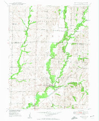
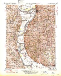 1947 Glasgow1947 Print · USGSThe Missouri River bottomlands in the mid-1940s reveal a landscape of shifting channels and established river towns. You can trace early settlement patterns through numerous rural landmarks like Sappington Cem, Boonesboro, and Farmers High Sch.2 unique versions available
 - 1949 Map of Mendon
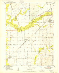 1949 Mendon1949 Print · USGSChariton County at the end of the 1940s shows a landscape of rail-driven settlements and protected wetlands. Trace the junctions of the Wabash railroad at Whitham or locate old community landmarks like Stephenson Sch and Jackson Cem.3 unique versions available
 - 1949 Map of Indian Grove
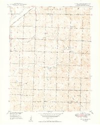 1949 Indian Grove1949 Print · USGSMid-century Chariton County comes to life here through its dense network of rural schoolhouses and country churches. You can trace early burial sites like Old Mendon Cem and locate vanished landmarks such as Woods Sch and the St Raphael Ch.4 unique versions available
 - 1949 Map of Sumner
 1949 Sumner1949 Print · USGSThe rail-and-river landscape of Chariton County is captured here in the late 1940s as agriculture and conservation efforts began to shape the terrain. Researchers can locate vanished landmarks like the Forker Boomer PO, rural schools such as Kaye Sch, and local resting places like Purvis Cem.2 unique versions available
 - 1949 Map of Rothville
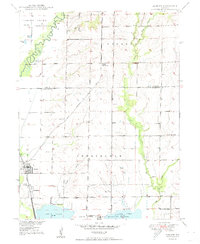
 1949 Rothville1949 Print · USGSChariton and Linn Counties are captured here just after the war, showing a rural landscape defined by rail and creek bottoms. Researchers can trace ancestral locations through several country schools like Pershing Sch and landmarks like Stains Cem.2 unique versions available
End of results
Showing maps 1-5 of 5
Top cities of Chariton County
- Salisbury historical maps
- Brunswick historical maps
- Keytesville historical maps
- Cunningham historical maps
- Mendon historical maps
- Sumner historical maps
See more
Frequently asked questions
- What are the different types of historical maps available for Chariton County?
- What is the oldest map of Chariton County?
- Where can I purchase historical maps of Chariton County for my home or office?
- Where can I download high-res historical maps of Chariton County?
- Are there historical topographic maps available for Chariton County?
- Is there historical aerial imagery available for Chariton County?
- Where are historical maps of Chariton County sourced from?