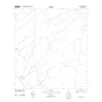
2012 Map of Salineno
USGS Topo · Published 2012About this map
Salineño and Falcon Heights occupy the river terrace overlooking the Rio Grande in this borderland survey. The landscape is defined by a series of significant drainage systems that carve through the scrubland toward the river, including Arroyo Morteros, Arroyo la Minita, and Arroyo Quemado. For genealogists and local historians, the Los Arrierous Cem stands near the southern bend of the river, situated along Los Arrieros Loop. The road network illustrates a transition from rural ranching routes like Ranch Road 2098 and San Julian Rd to more localized residential street grids. In the northeast, Saremente Cr drains the more sparsely populated ranch country, while the southern reaches follow the course of the Arroyo del Tigre.
Find a feature on this map
32 named features on this map. Tap any name to fly to it.
Don’t see what you’re looking for? This feature index may not catch every label — zoom into the map to look around manually.
Map Details
Editions of this 2012 Salineno Map
This is the sole edition of this map. No revisions or reprints were ever made.
Other maps of this area

1938 · Falcon
USGS Topo · 1:62,500

1938 · El Sauz
USGS Topo · 1:62,500

1949 · Mc Allen
USGS Topo · 1:250,000

1954 · McAllen
USGS Topo · 1:250,000

1956 · Escobares
USGS Topo · 1:62,500

1956 · Roma
USGS Topo · 1:62,500

1957 · Mc Allen
USGS Topo · 1:250,000

1962 · McAllen
USGS Topo · 1:250,000

1965 · Salineno
USGS Topo · 1:24,000
1965 · Falcon Village
USGS Topo · 1:24,000
Featured Places
- Falconaire Colonia, TX
- Jardin de San Julian Colonia, TX
- Falcon Heights, TX
- Salineño, TX
- Indio Number 1 Colonia, TX