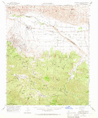
1964 Map of Salisbury Canyon
USGS Topo · Published 1966About this map
The Cuyama River valley and its surrounding high-country plateaus are documented here during a period of significant petroleum and agricultural development. The industrial footprint of the Cuyama Oil Field is visible near New Cuyama, a town characterized by its Cuyama Valley High Sch, Sewage Disposal plant, and Ranger Station. In the high mountain country to the south, the landscape is defined by vast grazing meadows known as potreros, including Montgomery Potrero and Salisbury Potrero, which were essential to the region's ranching heritage. Large landholdings like the Cuyama Ranch and the lands of the Heirs of Cesario Lataillade occupy the valley floor. The map also captures the early preservation efforts of the Sisquoc Condor Sanctuary along the southern edge of the Sierra Madre mountains.
Find a feature on this map
71 named features on this map. Tap any name to fly to it.
Don’t see what you’re looking for? This feature index may not catch every label — zoom into the map to look around manually.
Map Details
Editions of this 1964 Salisbury Canyon Map
This is the sole edition of this map. No revisions or reprints were ever made.
Other maps of this area

1902 · Santa Ynez
USGS Topo · 1:125,000

1903 · Mt. Pinos
USGS Topo · 1:125,000

1905 · Santa Ynez
USGS Topo · 1:125,000

1910 · Buena Vista Lake
USGS Topo · 1:125,000

1912 · McKittrick
USGS Topo · 1:125,000

1912 · Buena Vista Lake
USGS Topo · 1:125,000

1941 · San Rafael Mtn.
USGS Topo · 1:62,500

1941 · Caliente Mountain
USGS Topo · 1:62,500

1941 · McPherson Peak
USGS Topo · 1:62,500

1942 · San Rafael Mtn.
USGS Topo · 1:62,500