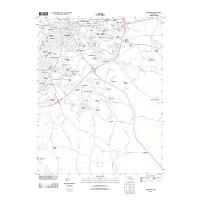
2011 Map of Salisbury
USGS Topo · Published 2011About this map
Salisbury University and the expansion of residential neighborhoods like Lincoln Heights and Highland Park characterize this Eastern Shore landscape during the early 21st century. The Wicomico River and its numerous tributaries, including the South Prong, define the city's internal geography and historical industrial sites such as Morris Millpond and Coulbourn Millpond. The map reveals a dense network of suburban developments stretching toward the Salisbury-Wicomico County Regional Airport in the east, while preserving older community landmarks such as the Wicomico Orphanage and Hustons Cemetery. To the south, the city of Fruitland remains distinct, centered around its own Fruitland Post Office and the Palmer Cemetery. This survey captures the transition from traditional mill-driven water management to modern recreational and residential land use, seen in the numerous ponds and golf courses like Nutters Crossing Golf Course.
Find a feature on this map
181 named features on this map. Tap any name to fly to it.
Don’t see what you’re looking for? This feature index may not catch every label — zoom into the map to look around manually.
Map Details
Editions of this 2011 Salisbury Map
This is the sole edition of this map. No revisions or reprints were ever made.
Other maps of this area

1901 · Snow Hill
USGS Topo · 1:62,500

1901 · Salisbury
USGS Topo · 1:62,500

1902 · Pittsville
USGS Topo · 1:62,500

1942 · Princess Anne
USGS Topo · 1:24,000

1942 · Snow Hill
USGS Topo · 1:24,000

1942 · Eden
USGS Topo · 1:24,000

1942 · Wango
USGS Topo · 1:24,000

1942 · Hebron
USGS Topo · 1:24,000

1942 · Dividing Creek
USGS Topo · 1:24,000

1942 · Salisbury
USGS Topo · 1:24,000