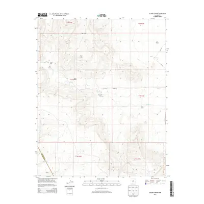
2013 Map of Salitre Canyon
USGS Topo · Published 2013About this map
Salitre Canyon and its network of winding drainages characterize this high-country landscape on the border of San Miguel and Harding counties. The terrain is deeply incised by Vigas Canyon, Tapia Canyon, and Mosquero Canyon, which channel seasonal water toward Mosquero Cr. This is a landscape shaped by ranching interests and isolated outposts, where named sites like Trujillo Ranch and McIntosh Camp represent the primary human footprint across the vast acreage. The presence of the McIntosh Windmill near the northern boundary highlights the essential role of water infrastructure in this arid region. To the southwest, the settlement of Wagoneer sits near the county line, while NM-39 skirts the eastern edge, providing the only major paved thoroughfare through the canyon systems.
Find a feature on this map
23 named features on this map. Tap any name to fly to it.
Don’t see what you’re looking for? This feature index may not catch every label — zoom into the map to look around manually.
Map Details
Editions of this 2013 Salitre Canyon Map
This is the sole edition of this map. No revisions or reprints were ever made.
Other maps of this area

1954 · Tucumcari
USGS Topo · 1:250,000

1958 · Tucumcari
USGS Topo · 1:250,000

1969 · Gallegos
USGS Topo · 1:24,000

1969 · Salitre Canyon
USGS Topo · 1:24,000
1969 · Alamosa Canyon
USGS Topo · 1:24,000
1969 · Campana
USGS Topo · 1:24,000

1969 · Chinaberry Canyon
USGS Topo · 1:24,000

1969 · Buffalo Springs
USGS Topo · 1:24,000

1973 · Circle Bar Ranch
USGS Topo · 1:24,000

1973 · Mosquero
USGS Topo · 1:24,000