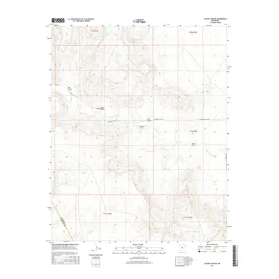
2017 Map of Salitre Canyon
USGS Topo · Published 2017About this map
Salitre Canyon and Mosquero Canyon dominate this high-plains landscape where the Harding Co and San Miguel Co lines meet in northeastern New Mexico. This 2017 survey details the complex drainage systems that feed into Mosquero Cr and Atarque Cr, illustrating how water has carved the terrain into named landforms such as Vigas Canyon, Ojos Canyon, and Tapia Canyon. Human presence is marked by a sparse network of cattle guards and unpaved arteries, including Mosquero Canyon Rd and Co Rd J. The topography reflects the transitional nature of the Canadian River basin's tributary canyons, providing a technical look at the section lines and township boundaries that define modern land ownership in this ranching country.
Find a feature on this map
17 named features on this map. Tap any name to fly to it.
Don’t see what you’re looking for? This feature index may not catch every label — zoom into the map to look around manually.
Map Details
Editions of this 2017 Salitre Canyon Map
This is the sole edition of this map. No revisions or reprints were ever made.
Other maps of this area

1954 · Tucumcari
USGS Topo · 1:250,000

1958 · Tucumcari
USGS Topo · 1:250,000

1969 · Gallegos
USGS Topo · 1:24,000

1969 · Salitre Canyon
USGS Topo · 1:24,000
1969 · Alamosa Canyon
USGS Topo · 1:24,000
1969 · Campana
USGS Topo · 1:24,000

1969 · Chinaberry Canyon
USGS Topo · 1:24,000

1969 · Buffalo Springs
USGS Topo · 1:24,000

1973 · Circle Bar Ranch
USGS Topo · 1:24,000

1973 · Mosquero
USGS Topo · 1:24,000