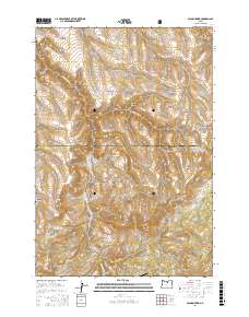
2017 Map of Salmon Fork
USGS Topo · Published 2017About this map
Salmon Fork and Thirtymile Cr carve through the high plateaus of Wheeler County on this modern geological survey, which illustrates the complex drainage systems of north-central Oregon. The map centers on a deeply dissected landscape where the Gilliam County and Wheeler County line bisects remote canyons. Historically, the region was defined by its proximity to the timber operations of the mid-20th century, a legacy reflected in the presence of the Kinzua Airport and the network of access roads like Kinzua Rd and Hoover Creek Rd. The southeastern corner of the quadrangle includes a portion of the Umatilla National Forest, providing a sense of the boundary between public lands and the private ranchlands of the basin. Distinctive landmarks such as Steamboat Rock and the towering Rettie Butte serve as navigation points among the numerous named drainages, including Jump Off Joe Canyon and Cabin Canyon.
Find a feature on this map
33 named features on this map. Tap any name to fly to it.
Don’t see what you’re looking for? This feature index may not catch every label — zoom into the map to look around manually.
Map Details
Editions of this 2017 Salmon Fork Map
This is the sole edition of this map. No revisions or reprints were ever made.
Other maps of this area

1916 · Condon
USGS Topo · 1:125,000

1926 · Mitchell
USGS Topo · 1:125,000

1953 · Spray
USGS Topo · 1:62,500

1953 · Pendleton
USGS Topo · 1:250,000

1953 · The Dalles
USGS Topo · 1:250,000

1955 · Bend
USGS Topo · 1:250,000

1955 · Canyon City
USGS Topo · 1:250,000

1956 · The Dalles
USGS Topo · 1:250,000

1956 · Pendleton
USGS Topo · 1:250,000

1957 · Bend
USGS Topo · 1:250,000