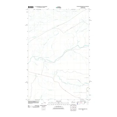
2011 Map of Salmon River West
USGS Topo · Published 2011About this map
The Salmon River and Queets River dominate this coastal river valley landscape, carving winding paths through the Olympic Peninsula's dense drainage network. These two major watercourses are fed by an intricate system of tributaries, including McKinnon Creek, Hurst Creek, and Harlow Creek, which suggest the heavy precipitation and active hydrology of the region. The map reveals a land primarily defined by its waterways and a managed forest infrastructure, evidenced by the presence of Bureau of Indian Affairs and National Forest development roads. While residential centers are absent, the network of routes like Bia 9200 RD and NFD 3000 RD provide access through the timberlands. In the southern portion of the quadrangle, the headwaters of the North Fork Raft River begin their descent toward the Pacific, marking the topographic transition between these significant river basins.
Find a feature on this map
21 named features on this map. Tap any name to fly to it.
Don’t see what you’re looking for? This feature index may not catch every label — zoom into the map to look around manually.
Map Details
Editions of this 2011 Salmon River West Map
This is the sole edition of this map. No revisions or reprints were ever made.
Other maps of this area

1943 · Copalis Beach
USGS Topo · 1:250,000

1951 · Copalis Beach
USGS Topo · 1:250,000

1955 · Taholah
USGS Topo · 1:62,500

1955 · Macafee Hill
USGS Topo · 1:62,500

1956 · Destruction Island
USGS Topo · 1:62,500

1956 · Salmon River
USGS Topo · 1:62,500

1957 · Copalis Beach
USGS Topo · 1:250,000

1963 · Copalis Beach
USGS Topo · 1:250,000
1980 · Copalis Beach
USGS Topo · 1:100,000
1982 · Tunnel Island
USGS Topo · 1:24,000