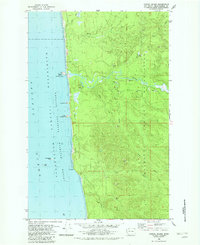
1982 Map of Tunnel Island
USGS Topo · Published 1982About this map
The Quinault Indian Reservation dominates this coastal landscape where the Raft River meets the Pacific Ocean. This 1982 survey illustrates a rugged interface between land and sea, marked by distinctive offshore formations including Tunnel Island, Elephant Rock, and Willoughby Rock within the Copalis Islands National Wildlife Refuge. The interior terrain is defined by a dense network of watercourses such as Red Creek, Camp Creek, and Duck Creek, which carve through the wooded uplands. While the area remains largely undeveloped, the presence of numerous Gravel Pits scattered along the river valley and ridges points to the localized industrial activity required for road maintenance and regional infrastructure. The map also captures geological landmarks like Pratt Cliff and the sea-carved Arch and Cave near the river mouth, providing a detailed record of this protected Washington shoreline.
Find a feature on this map
23 named features on this map. Tap any name to fly to it.
Don’t see what you’re looking for? This feature index may not catch every label — zoom into the map to look around manually.
Map Details
Editions of this 1982 Tunnel Island Map
2 editions found
Other maps of this area

1943 · Copalis Beach
USGS Topo · 1:250,000

1951 · Copalis Beach
USGS Topo · 1:250,000

1955 · Taholah
USGS Topo · 1:62,500

1955 · Macafee Hill
USGS Topo · 1:62,500

1956 · Destruction Island
USGS Topo · 1:62,500

1956 · Salmon River
USGS Topo · 1:62,500

1957 · Copalis Beach
USGS Topo · 1:250,000

1963 · Copalis Beach
USGS Topo · 1:250,000
1980 · Copalis Beach
USGS Topo · 1:100,000
1982 · Taholah
USGS Topo · 1:24,000