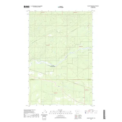
2020 Map of Salmon River West
USGS Topo · Published 2020About this map
Olympic National Park encompasses a significant portion of this landscape, protecting the river corridors and dense coastal forests along the border of Jefferson and Grays Harbor counties. The Queets River winds through the central terrain, passing through Lyman Rapids, while the Salmon River and the N Fork Raft River define the drainage patterns to the south. A network of specialized access routes, including Queets River Rd and Bureau of Indian Affairs roads like Bia Rd 9200, provide the primary navigation through these protected timberlands and river valleys. Numerous smaller drainages such as McKinnon Cr, Harlow Cr, and Tacoma Cr feed into the larger river systems, illustrating the complex watershed of the Olympic Peninsula's western slopes.
Find a feature on this map
30 named features on this map. Tap any name to fly to it.
Don’t see what you’re looking for? This feature index may not catch every label — zoom into the map to look around manually.
Map Details
Editions of this 2020 Salmon River West Map
This is the sole edition of this map. No revisions or reprints were ever made.
Other maps of this area

1943 · Copalis Beach
USGS Topo · 1:250,000

1951 · Copalis Beach
USGS Topo · 1:250,000

1955 · Taholah
USGS Topo · 1:62,500

1955 · Macafee Hill
USGS Topo · 1:62,500

1956 · Destruction Island
USGS Topo · 1:62,500

1956 · Salmon River
USGS Topo · 1:62,500

1957 · Copalis Beach
USGS Topo · 1:250,000

1963 · Copalis Beach
USGS Topo · 1:250,000
1980 · Copalis Beach
USGS Topo · 1:100,000
1982 · Tunnel Island
USGS Topo · 1:24,000