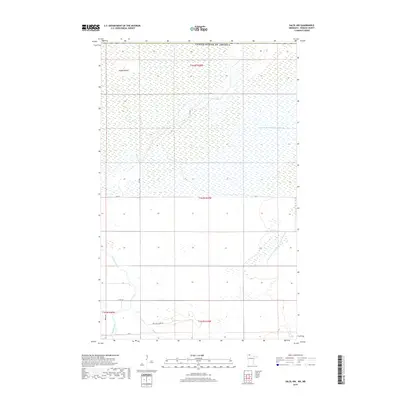
2019 Map of Salol NW
USGS Topo · Published 2019About this map
Roseau River meanders through this low-lying landscape in northern Roseau County, where the hydrology is defined by a mix of natural waterways and early 20th-century drainage projects. The map documents the extensive wetlands characteristic of the region, punctuated by elevated terrain such as Popple Island. This area, situated just south of the United States border, shows a transition from structured township grids to more fluid natural features. Modern infrastructure like Co Rd 28 and Mattson Island Rd provide access to the remote interior, while the presence of Judicial Ditch Number Sixtyone illustrates the historical effort to manage the local water table for agricultural use. Small watercourses like Hay Cr and the Lost River further define the drainage patterns of this rural Minnesota terrain.
Find a feature on this map
16 named features on this map. Tap any name to fly to it.
Don’t see what you’re looking for? This feature index may not catch every label — zoom into the map to look around manually.
Map Details
Editions of this 2019 Salol NW Map
This is the sole edition of this map. No revisions or reprints were ever made.
Other maps of this area

1918 · Goos
USGS Topo · 1:62,500

1918 · Roseau
USGS Topo · 1:62,500

1943 · Goos
USGS Topo · 1:62,500

1954 · Roseau
USGS Topo · 1:250,000

1957 · Roseau
USGS Topo · 1:250,000

1958 · Roseau
USGS Topo · 1:250,000

1963 · Kenora
USGS Topo · 1:250,000

1966 · Salol NW
USGS Topo · 1:24,000

1966 · Malung
USGS Topo · 1:24,000
1966 · Roseau
USGS Topo · 1:24,000