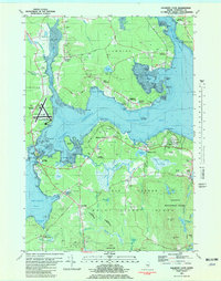
1981 Map of Salsbury Cove
USGS Topo · Published 1982About this map
Acadia Nat Park anchors the southern portion of this coastal survey, where the rugged shoreline of Mount Desert Island meets the waters of Eastern Bay. This region is defined by its maritime landscape, featuring intricate inlets like Jordan River and Skillings River that carved the mainland into necks and points. The map documents the early 1980s infrastructure serving the area, most notably the Hancock Co-Bar Harbor Airport and its accompanying Seaplane Ramp. Along the northern shores, the communities of Lamoine Corner and Marlboro remain tied to the water, while the interior of Lamoine is dotted with numerous gravel pits, indicating the local reliance on geological resources. Historic cemeteries like Forest Hill Cem and Hillside Cem are carefully noted, providing valuable data for genealogists tracing families in settlements such as Salsbury Cove and Town Hill.
Find a feature on this map
93 named features on this map. Tap any name to fly to it.
Don’t see what you’re looking for? This feature index may not catch every label — zoom into the map to look around manually.
Map Details
Editions of this 1981 Salsbury Cove Map
2 editions found
Other maps of this area

1904 · Mount Desert
USGS Topo · 1:62,500

1904 · Bar Harbor
USGS Topo · 1:62,500

1911 · Ellsworth
USGS Topo · 1:62,500

1930 · Tunk Lake
USGS Topo · 1:48,000

1932 · Tunk Lake
USGS Topo · 1:62,500

1940 · Ellsworth
USGS Topo · 1:62,500

1942 · Bar Harbor
USGS Topo · 1:62,500

1942 · Ellsworth
USGS Topo · 1:62,500

1942 · Mount Desert
USGS Topo · 1:62,500

1942 · Tunk Lake
USGS Topo · 1:62,500