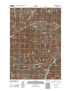
2011 Map of Salt Butte
USGS Topo · Published 2011About this map
Salt Butte and the surrounding high country of Crook County are defined by a complex network of seasonal water sources and isolated livestock landmarks. In the northern reaches, Ray Spring and Horse Spring provide critical water points in the shadow of the butte, while the southern terrain is dominated by the dramatic rock formations of Brennan Palisades and the high elevation of Mahogany Butte. The distribution of Slayton Corral and the Cow Camp Cabin reflects the traditional ranching use of the land. Waterways like Little McKay Creek and Evans Creek carve through the landscape, alongside smaller features like Kidnap Spring and A-Y Spring. Navigation through this area relies on established routes such as McKay Creek Rd and Old Dry Creek Rd, connecting the scattered springs and camps.
Find a feature on this map
30 named features on this map. Tap any name to fly to it.
Don’t see what you’re looking for? This feature index may not catch every label — zoom into the map to look around manually.
Map Details
Editions of this 2011 Salt Butte Map
This is the sole edition of this map. No revisions or reprints were ever made.
Other maps of this area

1948 · Ochoco Reservoir
USGS Topo · 1:62,500

1950 · Ochoco Reservoir
USGS Topo · 1:62,500

1955 · Bend
USGS Topo · 1:250,000

1957 · Bend
USGS Topo · 1:250,000

1958 · Bend
USGS Topo · 1:250,000

1962 · Prineville
USGS Topo · 1:24,000

1962 · Prineville
USGS Topo · 1:62,500

1968 · Dutchman Creek
USGS Topo · 1:24,000

1968 · Opal Mountain
USGS Topo · 1:24,000
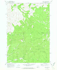
1969 · Foley Butte
USGS Topo · 1:24,000