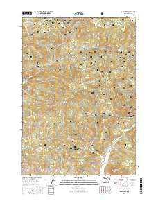
2017 Map of Salt Butte
USGS Topo · Published 2017About this map
The Ochoco National Forest dominates this section of the Ochoco Mountains, where the landscape is defined by high volcanic plateaus and steep drainages. Significant natural landmarks like Salt Butte and Green Mtn rise above the terrain, while the distinctive Brennan Palisades stand near the confluence of several seasonal drainages. The area’s hydrology is traced through numerous water sources, including Ray Spring, Whitetail Spring, and the curiously named Kidnap Spring.
Find a feature on this map
40 named features on this map. Tap any name to fly to it.
Don’t see what you’re looking for? This feature index may not catch every label — zoom into the map to look around manually.
Map Details
Editions of this 2017 Salt Butte Map
This is the sole edition of this map. No revisions or reprints were ever made.
Other maps of this area

1948 · Ochoco Reservoir
USGS Topo · 1:62,500

1950 · Ochoco Reservoir
USGS Topo · 1:62,500

1955 · Bend
USGS Topo · 1:250,000

1957 · Bend
USGS Topo · 1:250,000

1958 · Bend
USGS Topo · 1:250,000

1962 · Prineville
USGS Topo · 1:24,000

1962 · Prineville
USGS Topo · 1:62,500

1968 · Dutchman Creek
USGS Topo · 1:24,000

1968 · Opal Mountain
USGS Topo · 1:24,000
1969 · Foley Butte
USGS Topo · 1:24,000