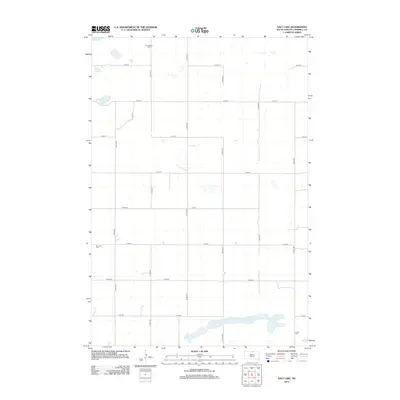
2012 Map of Salt Lake
USGS Topo · Published 2012About this map
Salt Lake sits at the southern edge of this Campbell County landscape, defined by its wide, irregular shoreline and the surrounding network of section-line roads. This rural expanse in the early 21st century remains largely agricultural, structured by a grid of numbered thoroughfares including 310th Ave and 115th St. Scattered across the prairie are several small water bodies such as Goehring Lake and a portion of Big Lake, which likely serve as vital landmarks in this open terrain.
Find a feature on this map
20 named features on this map. Tap any name to fly to it.
Don’t see what you’re looking for? This feature index may not catch every label — zoom into the map to look around manually.
Map Details
Editions of this 2012 Salt Lake Map
This is the sole edition of this map. No revisions or reprints were ever made.
Other maps of this area

1953 · McIntosh
USGS Topo · 1:250,000

1954 · Aberdeen
USGS Topo · 1:250,000

1956 · Aberdeen
USGS Topo · 1:250,000

1958 · McIntosh
USGS Topo · 1:250,000

1965 · Herreid
USGS Topo · 1:24,000

1967 · Mound City
USGS Topo · 1:24,000

1967 · Selby
USGS Topo · 1:24,000

1978 · Salt Lake
USGS Topo · 1:24,000

1978 · Java SE
USGS Topo · 1:24,000
1978 · Java
USGS Topo · 1:24,000