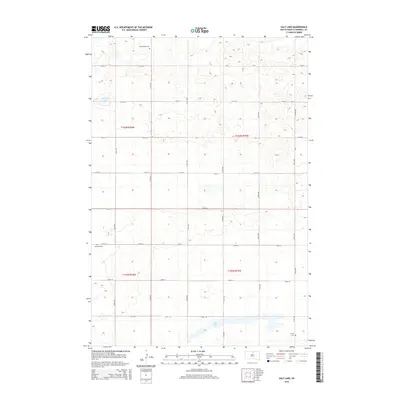
2015 Map of Salt Lake
USGS Topo · Published 2015About this map
Salt Lake and Goehring Lake anchor this agricultural landscape in eastern Campbell County, where the terrain is defined by the Public Land Survey System's precise grid. The map reveals a rural network of section-line roads, including 310th Ave and 120th St, that partition the prairie into a patchwork of fields. For those tracing family histories in this part of South Dakota, the map identifies three specific burial sites scattered across the townships: Knodenfeldt Cem in the north, Brockels Cem further south, and Sutley Cem near the southeastern shore of the main lake. This 2015 survey reflects the enduring pattern of High Plains settlement, where the small family-named cemeteries and the seasonal fluctuations of local water bodies remain the most prominent landmarks in an otherwise open, productive landscape.
Find a feature on this map
23 named features on this map. Tap any name to fly to it.
Don’t see what you’re looking for? This feature index may not catch every label — zoom into the map to look around manually.
Map Details
Editions of this 2015 Salt Lake Map
This is the sole edition of this map. No revisions or reprints were ever made.
Other maps of this area

1953 · McIntosh
USGS Topo · 1:250,000

1954 · Aberdeen
USGS Topo · 1:250,000

1956 · Aberdeen
USGS Topo · 1:250,000

1958 · McIntosh
USGS Topo · 1:250,000

1965 · Herreid
USGS Topo · 1:24,000

1967 · Mound City
USGS Topo · 1:24,000

1967 · Selby
USGS Topo · 1:24,000

1978 · Salt Lake
USGS Topo · 1:24,000

1978 · Java SE
USGS Topo · 1:24,000
1978 · Java
USGS Topo · 1:24,000