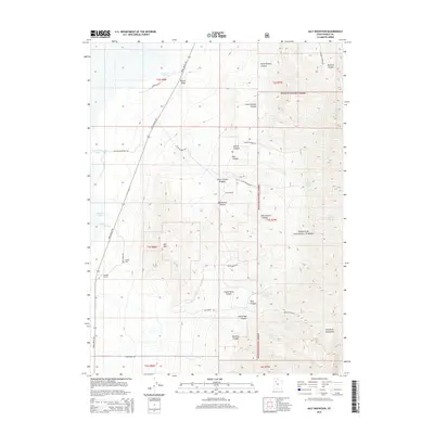
2014 Map of Salt Mountain
USGS Topo · Published 2014About this map
Iosepa Cem sits at the base of the Stansbury Mountains, serving as a poignant marker of the historical Polynesian settlement in the high desert of Tooele County. This arid landscape is defined by the sharp transition from the valley floor to the timbered heights of the Wasatch National Forest. Strategic water sources like Horseshoe Springs, Delle Springs, and the marshy Kanaka Lake have dictated land use for generations, supporting cattle operations at Delle Ranch and Deseret Ranch. Transportation follows the path of least resistance along Skull Valley Rd, while the eastern portion of the map is dominated by a complex network of drainages including Big Granite Canyon, Monument Canyon, and Chokecherry Canyon. The prominent height of Salt Mtn provides a central landmark in this basin-and-range terrain.
Find a feature on this map
45 named features on this map. Tap any name to fly to it.
Don’t see what you’re looking for? This feature index may not catch every label — zoom into the map to look around manually.
Map Details
Editions of this 2014 Salt Mountain Map
This is the sole edition of this map. No revisions or reprints were ever made.
Other maps of this area

1885 · Tooele Valley
USGS Topo · 1:250,000

1953 · Tooele
USGS Topo · 1:250,000

1955 · Timpie
USGS Topo · 1:62,500

1955 · Deseret Peak
USGS Topo · 1:62,500

1955 · Tooele
USGS Topo · 1:250,000

1973 · Hastings Pass NE
USGS Topo · 1:24,000

1973 · Hickman Knolls
USGS Topo · 1:24,000
1973 · Hastings Pass SE
USGS Topo · 1:24,000

1979 · Rush Valley
USGS Topo · 1:100,000
1979 · Tooele
USGS Topo · 1:100,000