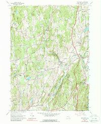
1963 Map of Salt Point
USGS Topo · Published 1988About this map
Wappinger Creek and its tributary, Little Wappinger Creek, define the topography of this central Dutchess County landscape, where agriculture and small hamlets remained the primary focus through the early 1960s. The region is marked by a network of historic settlements like Salt Point, Clinton Corners, and Washington Hollow, many connected by the winding Salt Point Turnpike. The social fabric of these rural communities is visible through landmarks such as Westminster Ch, Central Ch, and the Netherwood Sch. Local genealogy is well-represented by the Upton Lake Cem near the Stanford boundary. The map reveals a transition toward recreational land use with several camps, including Camp Nooteeming and Camp Eaton, interspersed among family-named terrain features like Cookingham Hill and Dennis Hill. Extensive Gravel Pits suggest the ongoing importance of local mineral extraction to the local economy during this era.
Find a feature on this map
75 named features on this map. Tap any name to fly to it.
Don’t see what you’re looking for? This feature index may not catch every label — zoom into the map to look around manually.
Map Details
Editions of this 1963 Salt Point Map
Other maps of this area

1893 · Clove
USGS Topo · 1:62,500

1893 · Poughkeepsie
USGS Topo · 1:62,500

1894 · Clove
USGS Topo · 1:62,500

1894 · Poughkeepsie
USGS Topo · 1:62,500

1898 · Clove
USGS Topo · 1:62,500

1898 · Rhinebeck
USGS Topo · 1:62,500

1899 · Millbrook
USGS Topo · 1:62,500

1901 · Clove
USGS Topo · 1:62,500

1902 · Millbrook
USGS Topo · 1:62,500

1903 · Poughkeepsie
USGS Topo · 1:62,500