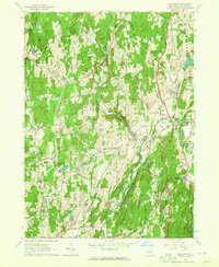
1963 Map of Salt Point
USGS Topo · Published 1964About this map
Wappinger Creek and its tributaries carve through this pocket of Dutchess County, defining a landscape of agricultural valleys and wooded ridges such as Cookingham Hill and Prospect Hill. By the early 1960s, the area remained largely rural, characterized by small hamlet centers like Salt Point, Clinton Hollow, and Hibernia. The map captures a high density of local institutions, including the Netherwood Sch, Westminster Ch, and St Josephs Ch, which served these dispersed farming communities.
Find a feature on this map
48 named features on this map. Tap any name to fly to it.
Don’t see what you’re looking for? This feature index may not catch every label — zoom into the map to look around manually.
Map Details
Editions of this 1963 Salt Point Map
Other maps of this area

1893 · Clove
USGS Topo · 1:62,500

1893 · Poughkeepsie
USGS Topo · 1:62,500

1894 · Clove
USGS Topo · 1:62,500

1894 · Poughkeepsie
USGS Topo · 1:62,500

1898 · Clove
USGS Topo · 1:62,500

1898 · Rhinebeck
USGS Topo · 1:62,500

1899 · Millbrook
USGS Topo · 1:62,500

1901 · Clove
USGS Topo · 1:62,500

1902 · Millbrook
USGS Topo · 1:62,500

1903 · Poughkeepsie
USGS Topo · 1:62,500