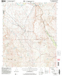
2004 Map of Salt River Peak
USGS Topo · Published 2007About this map
Salt River and Pinto Creek converge within a landscape defined by the deep incisions of Shute Canyon and the high elevations of the Superstition Wilderness. This 2004 revision of the 1981 survey reveals a territory primarily managed by the Tonto National Forest, where resource management is divided between the Globe Ranger District and Tonto Basin Ranger District. Human activity is concentrated around Roosevelt Resort and infrastructure like the Gaging Station and various adits indicating past mining exploration.
Find a feature on this map
59 named features on this map. Tap any name to fly to it.
Don’t see what you’re looking for? This feature index may not catch every label — zoom into the map to look around manually.
Map Details
Editions of this 2004 Salt River Peak Map
This is the sole edition of this map. No revisions or reprints were ever made.
Other maps of this area

1900 · Florence
USGS Topo · 1:125,000

1901 · Globe
USGS Topo · 1:62,500

1902 · Globe
USGS Topo · 1:62,500

1902 · Florence
USGS Topo · 1:125,000

1907 · Roosevelt
USGS Topo · 1:125,000

1909 · Four Peaks
USGS Topo · 1:125,000

1912 · Roosevelt
USGS Topo · 1:125,000

1922 · Chrysotile
USGS Topo · 1:125,000

1945 · Globe
USGS Topo · 1:24,000

1945 · Inspiration
USGS Topo · 1:24,000