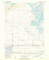
1951 Map of Saltair
USGS Topo · Published 1963About this map
The Saltair resort district on the southern edge of the Great Salt Lake marks a unique intersection of industrial salt production and recreational duck hunting during the early 1950s. Expansive Salt Evaporators and a massive Tailings Pond dominate the southwestern landscape, while the marshy wetlands to the northeast are dotted with private sporting camps like the Lake Front Duck Club and Utah Duck Club.
Find a feature on this map
29 named features on this map. Tap any name to fly to it.
Don’t see what you’re looking for? This feature index may not catch every label — zoom into the map to look around manually.
Map Details
Editions of this 1951 Saltair Map
2 editions found
Other maps of this area

1885 · Salt Lake
USGS Topo · 1:250,000

1885 · Tooele Valley
USGS Topo · 1:250,000

1925 · Ft. Douglas
USGS Topo · 1:125,000

1928 · Ft. Douglas
USGS Topo · 1:125,000

1951 · Saltair
USGS Topo · 1:24,000

1951 · Salt Lake City South
USGS Topo · 1:24,000

1951 · Salt Lake City North
USGS Topo · 1:24,000

1952 · Saltair NE
USGS Topo · 1:24,000

1952 · Farmington
USGS Topo · 1:24,000

1952 · Magna
USGS Topo · 1:24,000