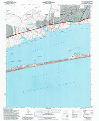
1994 Map of Salter Path
USGS Topo · Published 1997About this map
Croatan National Forest dominates the northern mainland of this coastal landscape, where the dense timber of the interior gives way to the tidal marshes of Bogue Sound. The mainland is marked by numerous freshwater branches like Wolf Br and Hannah Br that feed into the sound, while old timber and access routes such as Pringle Road and Nine Foot Road traverse the forest. This mid-1990s record captures the barrier island development along the southern reach of the sound, illustrating the expansion of Emerald Isle and the established communities of Indian Beach and Salter Path.
Find a feature on this map
41 named features on this map. Tap any name to fly to it.
Don’t see what you’re looking for? This feature index may not catch every label — zoom into the map to look around manually.
Map Details
Editions of this 1994 Salter Path Map
2 editions found
Other maps of this area

1942 · Maysville
USGS Topo · 1:62,500

1942 · Swansboro
USGS Topo · 1:62,500

1948 · Maysville
USGS Topo · 1:62,500

1948 · Swansboro
USGS Topo · 1:62,500

1949 · Newport
USGS Topo · 1:24,000

1949 · Salter Path
USGS Topo · 1:24,000

1949 · Mansfield
USGS Topo · 1:24,000

1949 · Masontown
USGS Topo · 1:24,000

1951 · Salter Path
USGS Topo · 1:24,000

1951 · Newport
USGS Topo · 1:24,000