
1963 Map of Salton Sea
USGS Topo · Published 1963About this map
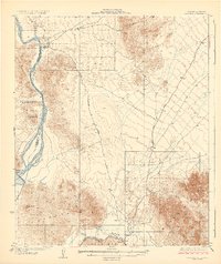
The Salton Sea dominates this arid landscape, flanked by the intensive irrigation networks of the Imperial Valley to the south. In the early 1960s, the region was a complex patchwork of conservation, agriculture, and military testing. The Salton Sea Test Base sits on the southwestern shore, while vast swaths of the Chocolate Mountains are designated as the Chocolate Mountain Aerial Gunnery Range and the Camp Dunlap Artillery Range.
Find a feature on this map
204 named features on this map. Tap any name to fly to it.
Don’t see what you’re looking for? This feature index may not catch every label — zoom into the map to look around manually.
Map Details
Editions of this 1963 Salton Sea Map
This is the sole edition of this map. No revisions or reprints were ever made.
Other maps of this area

1903 · Yuma
USGS Topo · 1:125,000

1904 · Indio
USGS Topo · 1:125,000

1905 · Yuma
USGS Topo · 1:125,000

1907 · Holtville
USGS Topo · 1:125,000

1911 · Parker
USGS Topo · 1:125,000

1915 · El Centro
USGS Topo · 1:125,000

1923 · Signal
USGS Topo · 1:250,000

1928 · Norton
USGS Topo · 1:62,500
1929 · Laguna
USGS Topo · 1:62,500

1929 · Norton
USGS Topo · 1:62,500