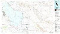
1985 Map of Salton Sea
USGS Topo · Published 1985About this map
The Salton Sea dominates the landscape of this 1980s Imperial County survey, framed by intensive irrigation and vast military reservations. To the south, the agricultural grid around Calipatria and Westmorland relies on the Alamo River and an intricate system of canals, while several lake units like Wiest Lake and Finney Lake provide managed habitats within the Salton Sea National Wildlife Refuge. The eastern half of the map is defined by the expanse of the Chocolate Mountains, much of which is occupied by the Chocolate Mountain Aerial Gunnery Range. Along the Southern Pacific rail line, small settlements such as Niland and Bombay Beach serve as outposts between the water's edge and the high desert. Mining activity is evident in the foothills, including the Black Eagle Mine and Frink Mine, indicating the persistent mineral extraction industries operating alongside the region's mid-century military installations like the Salton Sea Test Base.
Find a feature on this map
55 named features on this map. Tap any name to fly to it.
Don’t see what you’re looking for? This feature index may not catch every label — zoom into the map to look around manually.
Map Details
Editions of this 1985 Salton Sea Map
2 editions found
Other maps of this area

1903 · Yuma
USGS Topo · 1:125,000

1904 · Indio
USGS Topo · 1:125,000

1905 · Yuma
USGS Topo · 1:125,000

1907 · Holtville
USGS Topo · 1:125,000

1915 · El Centro
USGS Topo · 1:125,000

1931 · Vallecito
USGS Topo · 1:125,000

1931 · Carrizo
USGS Topo · 1:125,000

1940 · Brawley
USGS Topo · 1:62,500

1940 · Kane Spring
USGS Topo · 1:62,500

1940 · Iris
USGS Topo · 1:62,500