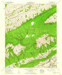
1958 Map of Saltville
USGS Topo · Published 1960About this map
Clinch Mountain and Brushy Mountain dominate this landscape, separating the narrow Poor Valley from the industrial activity centered on the North Fork Holston River. Industrial heritage is evident along the riverbanks, where the Olin Mathieson Chemical Corp RR and Norfolk and Western rail lines serve Saltville and its associated Muck pond. The map documents a dense network of family history, evidenced by nearly two dozen named burial sites including Vencill Cem, Bennett Cem, and Elizabeth Cem. Settlement patterns follow the valley floors, with small communities like Belfast, Cardwell Town, and Allison Gap positioned near the base of Little Mountain. Educational and spiritual life is anchored by R B Worthy High Sch, Belfast Sch, and local congregations at Harmony Church and New Bethel Ch.
Find a feature on this map
80 named features on this map. Tap any name to fly to it.
Don’t see what you’re looking for? This feature index may not catch every label — zoom into the map to look around manually.
Map Details
Editions of this 1958 Saltville Map
4 editions found
Other maps of this area

1891 · Tazewell
USGS Topo · 1:125,000

1891 · Abingdon
USGS Topo · 1:125,000

1894 · Abingdon
USGS Topo · 1:125,000

1895 · Tazewell
USGS Topo · 1:125,000

1897 · Tazewell
USGS Topo · 1:125,000

1909 · Abingdon
USGS Topo · 1:96,000

1911 · Abingdon
USGS Topo · 1:125,000

1912 · Pounding Mill
USGS Topo · 1:62,500

1915 · Richlands
USGS Topo · 1:48,000

1916 · Pounding Mill
USGS Topo · 1:62,500