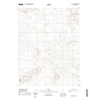
2020 Map of Salvation Creek
USGS Topo · Published 2020About this map
Capitol Reef National Park borders the southwestern corner of this Emery County map, where the terrain begins to descend into the Middle Desert. The landscape is defined by massive sedimentary formations, including the prominent Factory Butte and the Little Black Mountains in the south, while the northern reaches transition into Mussentuchit Flat and the elevations of Cedar Mtn. This area is shaped by seasonal watercourses such as Salvation Creek, Temple Wash, and Rock Springs Wash, which have carved the distinct topography seen at the Moroni Slopes. Historical resource extraction is noted at Oil Well Bench, while transportation through this desert environment is facilitated by the Lower Last Chance Loop and Co RD 920, reflecting the region's sparse infrastructure and remote character.
Find a feature on this map
15 named features on this map. Tap any name to fly to it.
Don’t see what you’re looking for? This feature index may not catch every label — zoom into the map to look around manually.
Map Details
Editions of this 2020 Salvation Creek Map
This is the sole edition of this map. No revisions or reprints were ever made.
Other maps of this area

1885 · Fish Lake
USGS Topo · 1:250,000

1896 · Fish Lake
USGS Topo · 1:250,000

1952 · Notom 2 NE
USGS Topo · 1:24,000

1952 · Torrey
USGS Topo · 1:62,500

1953 · Emery 4 NE
USGS Topo · 1:24,000

1953 · Emery 4 SE
USGS Topo · 1:24,000

1954 · Notom 1 NE
USGS Topo · 1:24,000

1954 · Fruita
USGS Topo · 1:62,500
1954 · Notom 1 NW
USGS Topo · 1:24,000

1956 · Salina
USGS Topo · 1:250,000