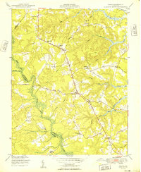
1949 Map of Samos
USGS Topo · Published 1949About this map
The Dragon Swamp and its associated wetlands, including Masons Mill Swamp and Wyatt Swamp, dominate the drainage patterns of this 1940s landscape. This survey, based on 1942 aerial photography, captures the rural character of Middlesex County before significant modern development. The George Washington Memorial Highway and the Tidewater Trail serve as the primary conduits through several small communities like Jamaica and Church View. Community life is clearly visible through the numerous centers of faith and education, such as the Glebe Landing Ch, Union Shiloh Sch, and Mt Zion Sch. The map also delineates the complex waterway network feeding into the Rappahannock R, including Lagrange Creek and Parrotts Creek, which shaped the early agricultural and milling economy of the region.
Find a feature on this map
45 named features on this map. Tap any name to fly to it.
Don’t see what you’re looking for? This feature index may not catch every label — zoom into the map to look around manually.
Map Details
Editions of this 1949 Samos Map
2 editions found
Other maps of this area

1917 · Urbanna
USGS Topo · 1:62,500

1917 · Morattico
USGS Topo · 1:62,500

1918 · Tappahannock
USGS Topo · 1:62,500

1918 · Morattico
USGS Topo · 1:62,500

1919 · New Kent
USGS Topo · 1:62,500

1919 · Tappahannock
USGS Topo · 1:62,500

1926 · Morattico
USGS Topo · 1:62,500

1943 · Richmond
USGS Topo · 1:250,000

1944 · Dunnsville
USGS Topo · 1:31,680

1944 · Morattico
USGS Topo · 1:31,680