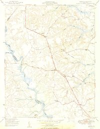
1949 Map of Samos
USGS Topo · Published 1949About this map
Dragon Swamp defines the western reaches of this Tidewater landscape, forming a natural boundary for Middlesex, King and Queen, and Essex counties. The late 1940s terrain is marked by a network of rural settlements and family-named roads, centered on the George Washington Memorial Highway and the historic Tidewater Trail. Significant community landmarks include Glebe Landing Ch and St Pauls Ch, alongside several educational hubs such as the Union Shiloh Sch and Mt Zion Sch.
Find a feature on this map
47 named features on this map. Tap any name to fly to it.
Don’t see what you’re looking for? This feature index may not catch every label — zoom into the map to look around manually.
Map Details
Editions of this 1949 Samos Map
2 editions found
Other maps of this area

1917 · Urbanna
USGS Topo · 1:62,500

1917 · Morattico
USGS Topo · 1:62,500

1918 · Tappahannock
USGS Topo · 1:62,500

1918 · Morattico
USGS Topo · 1:62,500

1919 · New Kent
USGS Topo · 1:62,500

1919 · Tappahannock
USGS Topo · 1:62,500

1926 · Morattico
USGS Topo · 1:62,500

1943 · Richmond
USGS Topo · 1:250,000

1944 · Dunnsville
USGS Topo · 1:31,680

1944 · Morattico
USGS Topo · 1:31,680