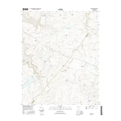
2016 Map of Sampson
USGS Topo · Published 2016About this map
Sampson sits atop the plateau where the border of Van Buren and Bledsoe counties meet, a landscape defined by sharp elevation changes and numerous watercourses. The drainage patterns are dominated by steep drops into the gulfs, such as Camps Gulf Br and Harrison Gulf Br, which feed into the Cane Creek system. This 2016 survey documents a rural environment where land use is dictated by the ridges and hollows, with roads like Salzer Mountain Rd and Firetower Rd following the high ground. Near the western edge, the dramatic descent toward Fall Creek Falls Lake and Cane Creek Falls marks one of the most significant topographic shifts in the region. Genealogists will find several family-named landmarks and resting places, including Mooneyham Cem, Walling Cem, and DeBord Cem, which are tucked away near the small settlements of Mooneyham and Sampson.
Find a feature on this map
91 named features on this map. Tap any name to fly to it.
Don’t see what you’re looking for? This feature index may not catch every label — zoom into the map to look around manually.
Map Details
Editions of this 2016 Sampson Map
This is the sole edition of this map. No revisions or reprints were ever made.
Other maps of this area

1892 · Pikeville
USGS Topo · 1:125,000

1895 · Pikeville
USGS Topo · 1:125,000

1909 · Sequatchie Valley
USGS Topo · 1:62,500

1910 · Pikeville
USGS Topo · 1:62,500

1912 · Crossville
USGS Topo · 1:62,500

1935 · Brockdell
USGS Topo · 1:24,000

1935 · Billingsley Gap
USGS Topo · 1:24,000
1935 · Pikeville
USGS Topo · 1:24,000

1935 · Smart Mountain
USGS Topo · 1:24,000

1943 · Cookeville
USGS Topo · 1:100,000