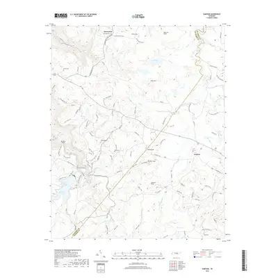
2019 Map of Sampson
USGS Topo · Published 2019About this map
Mooneyham and Sampson serve as the primary focal points of this portion of the Cumberland Plateau in Bledsoe and Van Buren counties. The landscape is defined by the headwaters of Camps Gulf Br, reflecting a region characterized by upland settlements and intricate drainage patterns. These communities developed along the high ridges and natural gaps of the plateau, where small-scale farming and timber interests shaped the local economy. The survey details the sparse road network connecting these remote settlements, providing a clear view of the rural infrastructure and land use in this part of Tennessee during the early 21st century.
Find a feature on this map
3 named features on this map. Tap any name to fly to it.
Don’t see what you’re looking for? This feature index may not catch every label — zoom into the map to look around manually.
Map Details
Editions of this 2019 Sampson Map
This is the sole edition of this map. No revisions or reprints were ever made.
Other maps of this area

1892 · Pikeville
USGS Topo · 1:125,000

1895 · Pikeville
USGS Topo · 1:125,000

1909 · Sequatchie Valley
USGS Topo · 1:62,500

1910 · Pikeville
USGS Topo · 1:62,500

1912 · Crossville
USGS Topo · 1:62,500

1935 · Brockdell
USGS Topo · 1:24,000

1935 · Billingsley Gap
USGS Topo · 1:24,000
1935 · Pikeville
USGS Topo · 1:24,000

1935 · Smart Mountain
USGS Topo · 1:24,000

1943 · Cookeville
USGS Topo · 1:100,000