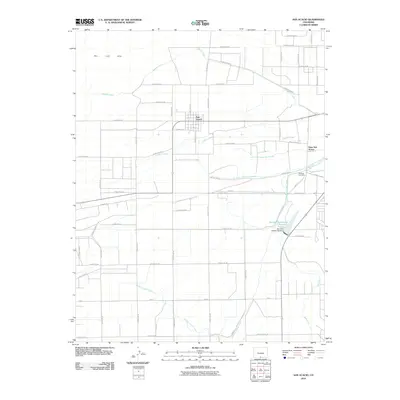
2010 Map of San Acacio
USGS Topo · Published 2010About this map
San Acacio and Viejo San Acacio anchor this high-desert agricultural landscape, where a sophisticated network of water management features allows for cultivation in the shadow of the San Luis Hills. The geography is defined by an intricate system of acequias and modern irrigation works, including the Cerritos Canal, Eastdale Culebra Canal, and the Mesa Ditch. These waterways draw from Culebra Creek and the significant storage capacity provided by the Sanchez Stabilizing Reservoir. Local history is centered near the Old Town Cemetery, which marks the earlier roots of the settlement pattern. The map reveals the precise layout of Sanchez Stabilizing Dam and various stock ditches, such as San Acacio Stock Ditch Number 2, illustrating the enduring reliance on gravity-fed water systems to sustain life and ranching in this portion of Costilla County.
Find a feature on this map
51 named features on this map. Tap any name to fly to it.
Don’t see what you’re looking for? This feature index may not catch every label — zoom into the map to look around manually.
Map Details
Editions of this 2010 San Acacio Map
This is the sole edition of this map. No revisions or reprints were ever made.
Other maps of this area

1954 · Trinidad
USGS Topo · 1:250,000

1955 · Trinidad
USGS Topo · 1:250,000

1958 · Trinidad
USGS Topo · 1:250,000

1959 · Trinidad
USGS Topo · 1:250,000

1965 · Lasauses
USGS Topo · 1:24,000

1965 · Blanca SE
USGS Topo · 1:24,000

1967 · San Luis
USGS Topo · 1:24,000

1967 · Fort Garland SW
USGS Topo · 1:24,000
1967 · Sky Valley Ranch
USGS Topo · 1:24,000
1967 · Mesito Reservoir
USGS Topo · 1:24,000