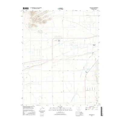
2016 Map of San Acacio
USGS Topo · Published 2016About this map
San Luis Hills rise in the northwest corner of this quadrangle, overlooking a complex network of agricultural irrigation that sustains the communities of San Acacio and Viejo San Acacio. This landscape is defined by its water management, featuring an intricate system of ditches and canals designed to divert flow from Culebra Cr. Key infrastructure such as the San Acacio Stock Ditch Number 1, San Acacio Stock Ditch Number 2, and the Cerritos Canal distribute water across the high desert plains. Toward the southeast, the Sanchez Stabilizing Reservoir and Mesa Ditch further illustrate the region's reliance on engineering to manage the arid environment. For genealogists, the Old Town Cem located near the original settlement site provides a specific point of interest for tracing early families in this part of Costilla County.
Find a feature on this map
40 named features on this map. Tap any name to fly to it.
Don’t see what you’re looking for? This feature index may not catch every label — zoom into the map to look around manually.
Map Details
Editions of this 2016 San Acacio Map
This is the sole edition of this map. No revisions or reprints were ever made.
Other maps of this area

1954 · Trinidad
USGS Topo · 1:250,000

1955 · Trinidad
USGS Topo · 1:250,000

1958 · Trinidad
USGS Topo · 1:250,000

1959 · Trinidad
USGS Topo · 1:250,000

1965 · Lasauses
USGS Topo · 1:24,000

1965 · Blanca SE
USGS Topo · 1:24,000

1967 · San Luis
USGS Topo · 1:24,000

1967 · Fort Garland SW
USGS Topo · 1:24,000
1967 · Sky Valley Ranch
USGS Topo · 1:24,000
1967 · Mesito Reservoir
USGS Topo · 1:24,000