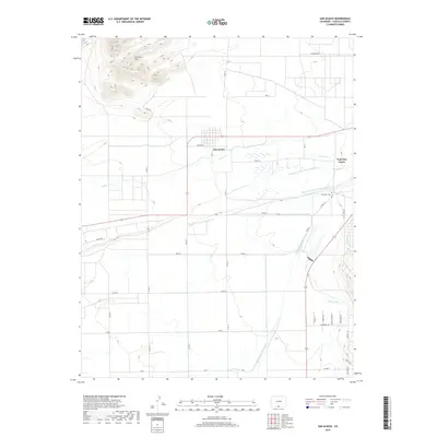
2019 Map of San Acacio
USGS Topo · Published 2019About this map
San Acacio and Viejo San Acacio anchor this high-altitude landscape in the southern San Luis Valley, where the arid environment is defined by an intricate network of irrigation systems. The reliance on water management is evident in the numerous channels branching from Culebra Cr, including the San Acacio Stock Ditch Number 1, San Acacio Stock Ditch Number 2, and the Eastdale-Culebra-Canal. These man-made waterways emphasize the agricultural heritage of Costilla County, carving through a terrain marked by the San Luis Hills in the northwest. Local history is grounded at the Old Town Cem near the eastern edge of the survey, while the southern reaches of the map show modern residential development patterns along roads like Chaparral Dr and Cuerna Verde Ct. The map captures a high-desert community where traditional ditch systems still dictate the flow of life and settlement.
Find a feature on this map
39 named features on this map. Tap any name to fly to it.
Don’t see what you’re looking for? This feature index may not catch every label — zoom into the map to look around manually.
Map Details
Editions of this 2019 San Acacio Map
This is the sole edition of this map. No revisions or reprints were ever made.
Other maps of this area

1954 · Trinidad
USGS Topo · 1:250,000

1955 · Trinidad
USGS Topo · 1:250,000

1958 · Trinidad
USGS Topo · 1:250,000

1959 · Trinidad
USGS Topo · 1:250,000

1965 · Lasauses
USGS Topo · 1:24,000

1965 · Blanca SE
USGS Topo · 1:24,000

1967 · San Luis
USGS Topo · 1:24,000

1967 · Fort Garland SW
USGS Topo · 1:24,000
1967 · Sky Valley Ranch
USGS Topo · 1:24,000
1967 · Mesito Reservoir
USGS Topo · 1:24,000