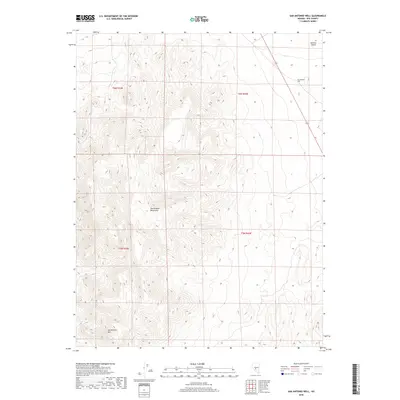
2018 Map of San Antonio Well
USGS Topo · Published 2018About this map
San Antonio Mountains and the adjacent San Antonio Mtn dominate the central and southern reaches of this Nye County landscape. This high-elevation desert terrain transitions sharply into the Ralston Desert to the northeast, where the vertical relief gives way to expansive basin floor. A single primary water source, San Antonio Well, is documented in the northern section of the quadrangle, a critical waypoint for travelers navigating this arid portion of the Great Basin. The 2018 survey also depicts the path of State Route 376 as it cuts across the northeastern corner, providing the modern transport link through this sparsely populated region of Nevada.
Find a feature on this map
9 named features on this map. Tap any name to fly to it.
Don’t see what you’re looking for? This feature index may not catch every label — zoom into the map to look around manually.
Map Details
Editions of this 2018 San Antonio Well Map
This is the sole edition of this map. No revisions or reprints were ever made.
Other maps of this area

1907 · Tonopah
USGS Topo · 1:250,000

1908 · Tonopah
USGS Topo · 1:250,000

1956 · Tonopah
USGS Topo · 1:250,000

1959 · Tonopah
USGS Topo · 1:250,000

1961 · Tonopah
USGS Topo · 1:62,500

1961 · Lone Mtn
USGS Topo · 1:62,500

1962 · Tonopah
USGS Topo · 1:250,000

1963 · Baxter Spring
USGS Topo · 1:62,500

1964 · San Antonio Ranch
USGS Topo · 1:62,500
1987 · Henrys Well
USGS Topo · 1:24,000