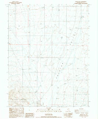
1987 Map of Henrys Well
USGS Topo · Published 1987About this map
The Ralston Valley dominates the eastern half of this terrain, showing a landscape defined by desert hydrology and early resource extraction. Centered near Henrys Well, the area is characterized by scattered Prospects and Gravel Pits that suggest a history of mineral exploration along the fringes of the San Antonio Mountains. This 1987 provisional edition, based on earlier surveys and aerial photography, reveals the sparse infrastructure of the high desert, including a Corral and isolated water sources like Willow Creek. The topographic detail highlights the relationship between the sloping valley floor and the rising mountain front, capturing a specific moment in the land use of Nye County prior to modern developments.
Find a feature on this map
11 named features on this map. Tap any name to fly to it.
Don’t see what you’re looking for? This feature index may not catch every label — zoom into the map to look around manually.
Map Details
Editions of this 1987 Henrys Well Map
This is the sole edition of this map. No revisions or reprints were ever made.
Other maps of this area

1907 · Tonopah
USGS Topo · 1:250,000

1908 · Tonopah
USGS Topo · 1:250,000

1956 · Tonopah
USGS Topo · 1:250,000

1959 · Tonopah
USGS Topo · 1:250,000

1961 · Tonopah
USGS Topo · 1:62,500

1962 · Tonopah
USGS Topo · 1:250,000

1963 · Baxter Spring
USGS Topo · 1:62,500

1971 · Antelope Spring
USGS Topo · 1:24,000
1971 · Big Ten Peak West
USGS Topo · 1:24,000
1986 · Hannapah
USGS Topo · 1:24,000