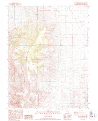
1987 Map of San Antonio Well
USGS Topo · Published 1987About this map
The San Antonio Mountains dominate this Nye County landscape, where the arid environment required a reliance on scattered water sources and mineral extraction. This 1987 provisional edition reveals the legacy of local mining efforts, centered on the San Antonio Mine and several nearby Prospects. These features indicate a history of exploration and industry in a territory where resources are sparse. Water access in this desert terrain is localized, evidenced by the San Antonio Well and a solitary Spring. The map provides a clear picture of the topography and the limited human footprint during the late 20th century, capturing the area before modern changes shifted the character of this mining and grazing land.
Find a feature on this map
5 named features on this map. Tap any name to fly to it.
Don’t see what you’re looking for? This feature index may not catch every label — zoom into the map to look around manually.
Map Details
Editions of this 1987 San Antonio Well Map
This is the sole edition of this map. No revisions or reprints were ever made.
Other maps of this area

1907 · Tonopah
USGS Topo · 1:250,000

1908 · Tonopah
USGS Topo · 1:250,000

1956 · Tonopah
USGS Topo · 1:250,000

1959 · Tonopah
USGS Topo · 1:250,000

1961 · Tonopah
USGS Topo · 1:62,500

1961 · Lone Mtn
USGS Topo · 1:62,500

1962 · Tonopah
USGS Topo · 1:250,000

1963 · Baxter Spring
USGS Topo · 1:62,500

1964 · San Antonio Ranch
USGS Topo · 1:62,500
1987 · Henrys Well
USGS Topo · 1:24,000