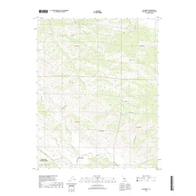
2018 Map of San Benito
USGS Topo · Published 2018About this map
The San Benito River winds through this Central Coast landscape, defining a corridor of ranching and transit in the southeastern reach of the county. The small settlement of San Benito sits at the junction of Old Hernandez Rd and Hernandez Rd, serving as a quiet focal point for the surrounding highlands. To the west, the boundary of Pinnacles National Park edges into the Gabilan Range, marking a transition from protected volcanic spires to the working ranch lands of the Call Mountains. Evidence of the area's complex topography is seen in features like The Hole and Pine Ridge, while historical transit is traced along Airline Hwy. The map details a network of canyons including Bosworth Canyon and Shields Canyon, which channel seasonal runoff toward the primary river valley, reflecting the importance of water management in this arid interior terrain.
Find a feature on this map
27 named features on this map. Tap any name to fly to it.
Don’t see what you’re looking for? This feature index may not catch every label — zoom into the map to look around manually.
Map Details
Editions of this 2018 San Benito Map
This is the sole edition of this map. No revisions or reprints were ever made.
Other maps of this area

1913 · Panoche
USGS Topo · 1:125,000

1915 · Priest Valley
USGS Topo · 1:125,000

1919 · San Benito
USGS Topo · 1:62,500

1921 · Metz
USGS Topo · 1:62,500

1931 · San Benito
USGS Topo · 1:62,500

1940 · Metz
USGS Topo · 1:62,500

1940 · San Benito
USGS Topo · 1:62,500

1943 · Hernandez Valley
USGS Topo · 1:62,500

1944 · Hernandez Valley
USGS Topo · 1:62,500

1944 · Panoche Valley
USGS Topo · 1:62,500