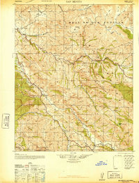
1940 Map of San Benito
USGS Topo · Published 1947About this map
San Benito serves as a central hub for this rural California landscape, where the San Benito River and Tres Pinos Creek carve through the California Mountains. The map reveals a decentralized community reliant on a network of one-room schoolhouses, including Cottonwood School, Live Oak School, and Emmett School, reflecting the era's educational infrastructure. Transportation is anchored by the Hollister and New Idria Road, which connects various remote ranching operations like Los Muertos and Elkhorn Ranch.
Find a feature on this map
40 named features on this map. Tap any name to fly to it.
Don’t see what you’re looking for? This feature index may not catch every label — zoom into the map to look around manually.
Map Details
Editions of this 1940 San Benito Map
2 editions found

Other maps of this area

1913 · Panoche
USGS Topo · 1:125,000

1915 · Soledad
USGS Topo · 1:62,500

1915 · Priest Valley
USGS Topo · 1:125,000

1919 · San Benito
USGS Topo · 1:62,500

1919 · Hollister
USGS Topo · 1:48,000

1921 · Gonzales
USGS Topo · 1:62,500

1921 · Metz
USGS Topo · 1:62,500

1921 · Hollister
USGS Topo · 1:62,500

1922 · Quien Sabe
USGS Topo · 1:62,500

1923 · Hollister
USGS Topo · 1:62,500