
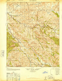
1940 Map of San Benito
USGS Topo · Published 1940About this map
The San Benito River carves a central path through this terrain where the Diablo Range and San Carlos Mountains converge. Revised just before the United States entered World War II, this tactical survey by the Corps of Engineers reflects a landscape defined by isolated ranching outposts and a network of small rural schoolhouses. Family-named landmarks such as Wilkinson Ranch and Huffs Ranch are scattered among the valleys, while the Bradford Mine indicates the era's local mineral interests.
Find a feature on this map
34 named features on this map. Tap any name to fly to it.
Don’t see what you’re looking for? This feature index may not catch every label — zoom into the map to look around manually.
Map Details
Editions of this 1940 San Benito Map
2 editions found
Other maps of this area

1913 · Panoche
USGS Topo · 1:125,000

1915 · Soledad
USGS Topo · 1:62,500

1915 · Priest Valley
USGS Topo · 1:125,000

1919 · San Benito
USGS Topo · 1:62,500

1919 · Hollister
USGS Topo · 1:48,000

1921 · Gonzales
USGS Topo · 1:62,500

1921 · Metz
USGS Topo · 1:62,500

1921 · Hollister
USGS Topo · 1:62,500

1922 · Quien Sabe
USGS Topo · 1:62,500

1923 · Hollister
USGS Topo · 1:62,500