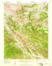
1957 Map of San Benito
USGS Topo · Published 1958About this map
Pinnacles National Monument anchors the southwestern corner of this survey, a landscape defined by the volcanic formations of Chalone Creek and the rugged drainage of the San Benito River. The territory shown reflects a mid-century California interior dominated by ranching and small-scale education, with dispersed properties like the Melendy Ranch, Schmidt Ranch, and McCreery Ranch situated along the seasonal watercourses of Tres Pinos Creek and Los Muertos Creek. The Airline Highway provides the primary north-south artery through Pinnacles Valley, connecting local landmarks such as Bear Valley School and the settlement of San Benito. Notable for genealogists is the distribution of rural institutions, including the Jefferson School and the Cottonwood School (Aban'd), alongside industrial traces like the Bradford Mine and conservation outposts like the Antelope Fire Control Station.
Find a feature on this map
64 named features on this map. Tap any name to fly to it.
Don’t see what you’re looking for? This feature index may not catch every label — zoom into the map to look around manually.
Map Details
Editions of this 1957 San Benito Map
2 editions found
Other maps of this area

1913 · Panoche
USGS Topo · 1:125,000

1915 · Soledad
USGS Topo · 1:62,500

1915 · Priest Valley
USGS Topo · 1:125,000

1919 · San Benito
USGS Topo · 1:62,500

1919 · Hollister
USGS Topo · 1:48,000

1921 · Gonzales
USGS Topo · 1:62,500

1921 · Metz
USGS Topo · 1:62,500

1921 · Hollister
USGS Topo · 1:62,500

1922 · Quien Sabe
USGS Topo · 1:62,500

1923 · Hollister
USGS Topo · 1:62,500