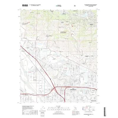
2018 Map of San Bernardino North
USGS Topo · Published 2018About this map
The San Bernardino National Forest dominates the northern half of this 2018 survey, where the rugged San Bernardino Mountains meet the expanding suburban landscape. From the resort-style mountain communities of Cedarpines Park and Valley of Enchantment to the dense street grids of San Bernardino and Muscovy, the map illustrates a complex relationship between wildland and urban development. Critical water infrastructure is highly visible, including the Governor Edmund G Brown E Br California Aqueduct and the Devil Creek Diversion Channel, which manage water flow through this dry environment. Geologic and educational landmarks also define the area, with the San Andreas Fault running along the base of the mountains near California State University-San Bernardino. Local history and legacy are preserved at sites like Mountain View Cem and the Arrowhead Springs Hot Lake at the canyon mouth.
Find a feature on this map
299 named features on this map. Tap any name to fly to it.
Don’t see what you’re looking for? This feature index may not catch every label — zoom into the map to look around manually.
Map Details
Editions of this 2018 San Bernardino North Map
This is the sole edition of this map. No revisions or reprints were ever made.
Other maps of this area

1896 · San Bernardino
USGS Topo · 1:62,500

1898 · San Bernardino
USGS Topo · 1:62,500

1899 · Redlands
USGS Topo · 1:62,500

1901 · Southern California Sheet No. 1
USGS Topo · 1:250,000

1901 · San Bernardino
USGS Topo · 1:62,500

1901 · Redlands
USGS Topo · 1:62,500

1902 · Deep Creek
USGS Topo · 1:62,500

1902 · Hesperia
USGS Topo · 1:62,500

1904 · Southern California Sheet No. 1
USGS Topo · 1:250,000

1936 · Devore
USGS Topo · 1:31,680