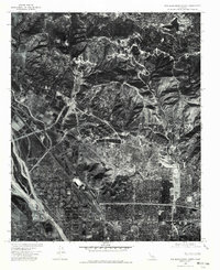
1975 Map of San Bernardino North
USGS Topo · Published 1979About this map
San Bernardino is seen here in a mid-1970s orthophotoquad, showing the dense grid of its northern neighborhoods as they met the steep ascent of the San Bernardino Mountains. This aerial perspective captures the complex interface between the urban sprawl and the towering ridge line that includes Arrowhead Peak. The map provides a high-resolution view of the industrial and residential transition into Rialto to the west and the mountain community of Crestline perched along the northern rim. The stark contrast between the structured city streets and the broad, braided expanse of Lytle Creek Wash illustrates the local management of alluvial fans and seasonal floodwaters. This imagery reveals the precise footprint of development before the continued expansion of the Inland Empire in the late twentieth century.
Find a feature on this map
5 named features on this map. Tap any name to fly to it.
Don’t see what you’re looking for? This feature index may not catch every label — zoom into the map to look around manually.
Map Details
Editions of this 1975 San Bernardino North Map
This is the sole edition of this map. No revisions or reprints were ever made.
Other maps of this area

1896 · San Bernardino
USGS Topo · 1:62,500

1898 · San Bernardino
USGS Topo · 1:62,500

1899 · Redlands
USGS Topo · 1:62,500

1901 · Southern California Sheet No. 1
USGS Topo · 1:250,000

1901 · San Bernardino
USGS Topo · 1:62,500

1901 · Redlands
USGS Topo · 1:62,500

1902 · Deep Creek
USGS Topo · 1:62,500

1902 · Hesperia
USGS Topo · 1:62,500

1904 · Southern California Sheet No. 1
USGS Topo · 1:250,000

1936 · Devore
USGS Topo · 1:31,680