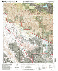
1996 Map of San Bernardino North
USGS Topo · Published 1999About this map
San Bernardino sits at the foot of the San Bernardino National Forest, where the developed valley floor meets the steep ascent toward Monument Peak. This mid-1990s revision reveals a landscape shaped by water management and institutional growth, featuring extensive Percolation Basins near the Santa Fe RR tracks and the established campus of California State University San Bernardino. The transition from urban density to mountain wilderness is sharp, with neighborhoods like Muscoy and Del Rosa giving way to the elevated communities of Crestline and Valley of the Moon. Local history is anchored by the Pioneer Cem and a dense network of educational and medical facilities, including St Bernardine Hospital and the San Bernardino High School, reflecting the city's role as a regional hub before the turn of the century.
Find a feature on this map
61 named features on this map. Tap any name to fly to it.
Don’t see what you’re looking for? This feature index may not catch every label — zoom into the map to look around manually.
Map Details
Editions of this 1996 San Bernardino North Map
This is the sole edition of this map. No revisions or reprints were ever made.
Other maps of this area

1896 · San Bernardino
USGS Topo · 1:62,500

1898 · San Bernardino
USGS Topo · 1:62,500

1899 · Redlands
USGS Topo · 1:62,500

1901 · Southern California Sheet No. 1
USGS Topo · 1:250,000

1901 · San Bernardino
USGS Topo · 1:62,500

1901 · Redlands
USGS Topo · 1:62,500

1902 · Deep Creek
USGS Topo · 1:62,500

1902 · Hesperia
USGS Topo · 1:62,500

1904 · Southern California Sheet No. 1
USGS Topo · 1:250,000

1936 · Devore
USGS Topo · 1:31,680